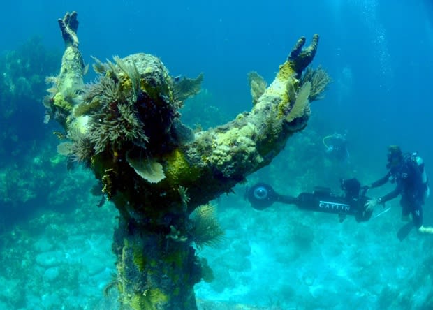
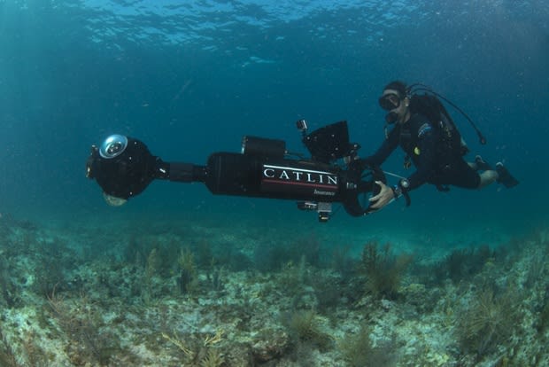
8月9日、フロリダ州キース、イスラモラーダの海中でパノラマ写真をテスト撮影するカメラマン。グーグルマップのストリートビューで近日中に見られるようになれればと科学者は期待している。(AP Photo/Catlin Seaview Survey)
![]()
Google ストリートビューで海底探検
2014.08.18 SankeiPhoto
グーグルは、アメリカ・フロリダ州の海中で今月初旬に行ったストリートビューの撮影の様子を公開した。海中での360度パノラマ写真は、ダイビングのライセンスを持っていなくても海に潜っているような感覚を楽しむことができる。またサンゴの生育環境の監視にも役立つという。
小型モーターがついたパノラマ撮影機材のほか、三脚でカメラを回しながら撮影する地上での撮影方法と同じ方法での撮影も行われている。今後、さらに撮影場所を増やしていく予定だ。
![]()
![]()
8月5日、フロリダ州キースの海中で撮影されたパノラマ写真。グーグルマップのストリートビューで近日中に見られるようになれればと科学者は期待している。(AP Photo/Catlin Seaview Survey)
![]()
In this Aug, 6, 2014 photo provided by Catlin Seaview Survey, Catlin's Christophe Bailhache surveys "Christ of the Abyss," with the SVII cameras off the coast of Key Largo, Fla. U.S. government scientists hope people will soon be able to go online and get a 360-degree view of reefs and other underwater wonders, much like Google Map’s “street view” lets people look at homes. (AP Photo/Catlin Seaview Survey, Philip Dunstan)
(機械翻訳)この8月に ― 6つ、2014の写真が、カトリンSeaview Surveyによって、定めた ― 非常にGoogle Mapの「通りの景色」が人々に家を見させるように、カトリンのクリストフ・ベラシュは、キーラーゴの沖合のSVIIカメラ、人々がオンライン化して、礁の360度の眺めを得ることがすぐにできるというフロリダ米国政府科学者望みと他の水中の驚きで、「Abyssのキリスト」を調査します。 (AP写真/カトリン海の景色調査、フィリップ・ダンスタン)
![]()
![]()
パノラマ撮影するカメラを準備する科学者。In this Monday, Aug, 11, 2014 photo, Mitchell Tartt, of the National Oceanic and Atmospheric Administration, readies a panoramic camera before heading out for a survey of the reefs, in Islamorada, Fla. U.S. government scientists are learning to use specialized fisheye lenses underwater in the Florida Keys this week in the hopes of applying 360-degree “street view” mapping to research and management plans in federal marine sanctuaries nationwide. (AP Photo/Alan Diaz)
(機械翻訳)この2014年8月11日月曜日には、Islamorada、米国政府科学者が360度の「通りの景色」マッピングを研究に適用する希望で今週フロリダキーズで専門魚眼レンズを水中で使うために学んでいるフロリダと全国的連邦海の聖域の管理計画では、海洋大気局の、写真(ミッチェル・タート)は、礁の測量のために去る前に、パノラマカメラを準備します。 (AP写真/アラン・ディアス)
![]()
水中モーターのついたパノラマ撮影機材 =8月9日、フロリダ州イスラモラーダ In this Monday, Aug, 11, 2014 photo, Richard Vevers, of Catlin Seaview Survey, left, and Mitchell Tartt, of the National Oceanic and Atmospheric Administration, right, carry a water scooter with SVII cameras as they prepare to survey the corals off the coast of Islamorada, Fla. U.S. government scientists hope people will soon be able to go online and get a 360-degree view of reefs and other underwater wonders, much like Google Map’s “street view” lets people look at homes. (AP Photo/Alan Diaz)
(機械翻訳)彼らがIslamoradaの沖合で珊瑚を調査する準備をして、この2014年8月11日月曜日には、カトリンSeaview Survey(残った)の写真(リチャード・ビバース)とミッチェル・タート(海洋大気局の)はSVIIカメラで水スクーターを持っています ― 人々がすぐにオンライン化することができて、礁と水中の他の360度の見方を得るというフロリダ米国政府科学者望みが不思議に思う ― Google Mapの「通りの景色」のような多くは人々に家を見させます。 (AP写真/アラン・ディアス)
★★ 水中のパノラマ写真はこちら ★★
![]()
着々と海の中道(リンク先は関係ないか 笑 )も解明されて行く。ここは涼しいだろう!ん?フロリダだ!reeさんのところ海だ!!!

Google ストリートビューで海底探検
2014.08.18 SankeiPhoto
グーグルは、アメリカ・フロリダ州の海中で今月初旬に行ったストリートビューの撮影の様子を公開した。海中での360度パノラマ写真は、ダイビングのライセンスを持っていなくても海に潜っているような感覚を楽しむことができる。またサンゴの生育環境の監視にも役立つという。
小型モーターがついたパノラマ撮影機材のほか、三脚でカメラを回しながら撮影する地上での撮影方法と同じ方法での撮影も行われている。今後、さらに撮影場所を増やしていく予定だ。


8月5日、フロリダ州キースの海中で撮影されたパノラマ写真。グーグルマップのストリートビューで近日中に見られるようになれればと科学者は期待している。(AP Photo/Catlin Seaview Survey)

In this Aug, 6, 2014 photo provided by Catlin Seaview Survey, Catlin's Christophe Bailhache surveys "Christ of the Abyss," with the SVII cameras off the coast of Key Largo, Fla. U.S. government scientists hope people will soon be able to go online and get a 360-degree view of reefs and other underwater wonders, much like Google Map’s “street view” lets people look at homes. (AP Photo/Catlin Seaview Survey, Philip Dunstan)
(機械翻訳)この8月に ― 6つ、2014の写真が、カトリンSeaview Surveyによって、定めた ― 非常にGoogle Mapの「通りの景色」が人々に家を見させるように、カトリンのクリストフ・ベラシュは、キーラーゴの沖合のSVIIカメラ、人々がオンライン化して、礁の360度の眺めを得ることがすぐにできるというフロリダ米国政府科学者望みと他の水中の驚きで、「Abyssのキリスト」を調査します。 (AP写真/カトリン海の景色調査、フィリップ・ダンスタン)


パノラマ撮影するカメラを準備する科学者。In this Monday, Aug, 11, 2014 photo, Mitchell Tartt, of the National Oceanic and Atmospheric Administration, readies a panoramic camera before heading out for a survey of the reefs, in Islamorada, Fla. U.S. government scientists are learning to use specialized fisheye lenses underwater in the Florida Keys this week in the hopes of applying 360-degree “street view” mapping to research and management plans in federal marine sanctuaries nationwide. (AP Photo/Alan Diaz)
(機械翻訳)この2014年8月11日月曜日には、Islamorada、米国政府科学者が360度の「通りの景色」マッピングを研究に適用する希望で今週フロリダキーズで専門魚眼レンズを水中で使うために学んでいるフロリダと全国的連邦海の聖域の管理計画では、海洋大気局の、写真(ミッチェル・タート)は、礁の測量のために去る前に、パノラマカメラを準備します。 (AP写真/アラン・ディアス)

水中モーターのついたパノラマ撮影機材 =8月9日、フロリダ州イスラモラーダ In this Monday, Aug, 11, 2014 photo, Richard Vevers, of Catlin Seaview Survey, left, and Mitchell Tartt, of the National Oceanic and Atmospheric Administration, right, carry a water scooter with SVII cameras as they prepare to survey the corals off the coast of Islamorada, Fla. U.S. government scientists hope people will soon be able to go online and get a 360-degree view of reefs and other underwater wonders, much like Google Map’s “street view” lets people look at homes. (AP Photo/Alan Diaz)
(機械翻訳)彼らがIslamoradaの沖合で珊瑚を調査する準備をして、この2014年8月11日月曜日には、カトリンSeaview Survey(残った)の写真(リチャード・ビバース)とミッチェル・タート(海洋大気局の)はSVIIカメラで水スクーターを持っています ― 人々がすぐにオンライン化することができて、礁と水中の他の360度の見方を得るというフロリダ米国政府科学者望みが不思議に思う ― Google Mapの「通りの景色」のような多くは人々に家を見させます。 (AP写真/アラン・ディアス)
★★ 水中のパノラマ写真はこちら ★★

着々と海の中道(リンク先は関係ないか 笑 )も解明されて行く。ここは涼しいだろう!ん?フロリダだ!reeさんのところ海だ!!!